Credit: Andrew Richardson
CONCERNS over Linburn Bridge at Hamsterley have escalated after a local resident submitted a detailed highway objection to Durham County Council, arguing that the bridge and surrounding road network have not been adequately assessed for increased traffic linked to the proposed Hamsterley Forest development.
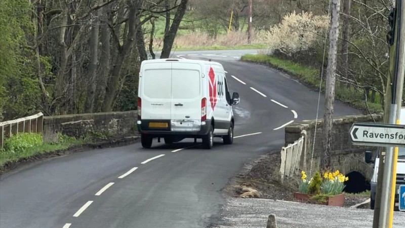
Andrew Richardson, a Hamsterley Forest resident, has submitted a further objection to planning application DM/24/02979/FPA, together with a separate evidence pack containing Durham County Council’s latest Environmental Information Regulations response and current photographs of the bridge. The objection centres on Linburn Bridge B0419 on the C30/Daniel Lane route, which has become increasingly important following the closure of the C31 and is now being used by a mixture of local traffic, large commercial vehicles and timber wagons.
Mr Richardson says the issue is not an allegation that the bridge is about to fail structurally. His objection instead asks whether the bridge and its approaches have been properly assessed for the intensity, size and mix of traffic now using the route and potentially generated by the proposed development. Council unable to identify key traffic assessments In an EIR response dated 12 August 2026, Durham County Council confirmed that Linburn Bridge is asset B0419 and said the 2025 Principal Inspection records an overall bridge width of 7.31 metres. However, the Council said it had identified no separate recorded figure for the minimum carriageway width between the internal faces of the stone parapets.
More significantly, DCC said searches had identified no recorded information falling within the request for: * road-safety assessments; * collision analysis; * reported safety concerns, complaints, incidents or near misses; * assessments of the bridge’s suitability for two-way traffic; * swept-path or vehicle-tracking assessments; * capacity assessments; * or records discussing vehicle conflict, restricted visibility or operational limitations.
That response is now the subject of a Regulation 11 internal review. Parish Council correspondence raises questions The internal review has become more significant after correspondence emerged showing that Hamsterley Parish Council had been raising concerns over Linburn Bridge with DCC from at least March 2025. The correspondence involved Ellis Dunn, DCC Traffic Engineer, and was later copied to Michelle McIntosh, Traffic Assets Team Leader, and Kieron Moralee, Traffic Management Section Manager, together with County Councillors Robert Potts and Tim McGuinness.
The Parish Council chronology also refers to a later reported near miss. Mr Richardson argues this appears difficult to reconcile with DCC’s formal EIR response stating that no relevant safety-concern or near-miss records had been identified. He is now asking the internal reviewer to establish exactly which departments, officer records and systems were searched. A separate strand of the objection concerns the June 2025 AECOM Principal Inspection of the bridge.
he report recorded significant deterioration since the previous Principal Inspection and identified defects affecting the parapets, spandrel masonry and other parts of the structure. Of particular concern to Andrew Richardson is a recorded minimum parapet height of approximately 780mm, together with a High-priority recommendation concerning parapet height and a recommended risk assessment. He stresses that this does not prove the bridge is structurally unsafe.
The objection instead asks what happened after those recommendations were received by DCC and whether the required risk assessment, monitoring or remedial work was carried out. Usable width remains disputed.
Another key point is the difference between the overall width of the bridge and the width actually available to traffic. DCC says its earlier statement that the bridge was between 7 and 8 metres wide originated from a site measurement intended to establish that the bridge exceeded the minimum width required for two-way traffic separated by a centre line. But the Council says it holds no further recorded information identifying the precise measurement, location, methodology or document relied upon.
Mr Richardson has also taken several indicative laser measurements across the usable road space, producing readings in the region of 5.3 to 5.7 metres. He accepts these are not a professional engineering survey and says their purpose is simply to demonstrate why an authoritative carriageway measurement is required. Engineering drawing withheld DCC has confirmed that a professional General Arrangement drawing exists: 60747718-ACM-B0419-DR-CE-001 but has refused disclosure under Regulation 12(5)(e), citing commercial confidentiality, contractual restrictions, copyright and proprietary engineering detail.
Mr Richardson is challenging that refusal. He argues that even if parts of the drawing are genuinely commercially sensitive, DCC should explain why basic factual dimensions such as the usable carriageway width, parapet-to-parapet width and verge widths could not be extracted or released in redacted form.
Timber wagons and diverted traffic. The objection also raises the changed traffic situation following the C31 closure. Large articulated timber wagons have been observed using the C30/Daniel Lane network, while further commercial harvesting is expected at Hamsterley Forest in the coming years. Richardson has submitted separate information requests to DCC and Forestry England seeking details of: * planned timber harvesting; * expected wagon numbers; * haulage frequency; * recognised or agreed routes; * and whether Linburn Bridge has been specifically assessed for timber traffic.
Those responses remain outstanding and are expected to form part of a later supplementary objection.
Development traffic: The planning application itself includes 70 Forest Holidays cabins, additional overnight accommodation at The Nest, visitor facilities and other development. The applicant’s transport evidence predicts that traffic approaching from the south would use Daniel Lane, avoiding the closed C31. Richardson’s objection also challenges reliance on a modelled peak of around 155 additional vehicle movements, pointing out that much of the accommodation trip-generation methodology is based on data from Forest Holidays Sherwood Pines rather than observed Hamsterley Forest accommodation traffic.
He argues that comparator data may estimate how many trips could be generated, but cannot demonstrate whether Linburn Bridge and Daniel Lane can safely accommodate those trips.
Policy 21 at the centre of the objection: The objection places particular emphasis on County Durham Plan Policy 21, which requires traffic generated by development to be capable of being safely accommodated on the highway network. It also cites national planning policy requiring safe and suitable access and consideration of cumulative highway-safety effects. Richardson says the planning question is therefore not simply how many vehicles the development might generate. It is whether the route they are expected to use has been properly assessed against: existing traffic, diverted traffic, timber wagons, construction HGVs, deliveries, service vehicles and long-term overnight visitor traffic.
He said: “The issue is not whether somebody can produce a traffic figure on a spreadsheet. The issue is whether the roads and bridge those vehicles will actually use have been properly assessed for the traffic they are now expected to carry.
“DCC’s own response says it cannot identify a two-way suitability assessment, vehicle tracking or capacity assessment for Linburn Bridge. At the same time, the actual usable carriageway width remains unresolved and a professional bridge drawing has been withheld.
“With community safety concerns, timber HGVs, diverted traffic and a major development all converging on the same route, these questions need answering before any final highways conclusion is reached.”
The objection and evidence pack have also been circulated to Cllr Robert Potts, Cllr Tim McGuinness, Hamsterley Parish Council, South Bedburn Parish Council, Paul Anderson at DCC Strategic Highways, and media contacts. Richardson says further evidence will be submitted once the EIR internal review and the outstanding timber-haulage information requests are completed.
Durham County Council was contacted and gave the following statement:
Andrew Lough, Durham County Council’s structures manager, said: “We carried out an in-depth examination of the bridge last year to determine that it was safe and structurally sound. We will be sending another inspector out this week to assess for any defects and plan any required works accordingly.
“We appreciate the importance of the bridge as a route in and out of the village, and we will continue to monitor it closely to ensure it is structurally safe.”